Blog & Resources
Education-heavy content built for buyers, search engines, AI search, and voice search. Each article connects drone capture to reports, evidence, decisions, and AssetGuard-ready records.
Blog & Resources documentation built around usable records.
New England projects often need records that account for weather, access, repair planning, contractor coordination, budget timing, and future comparison needs. NEDD does not deliver a unorganized photo set. The work is structured so owners, managers, contractors, carriers, and project teams can understand what was captured, what remains unknown, and what next step is most practical.
Site access, terrain, drainage paths, land features, structure locations, and map-style visual records.
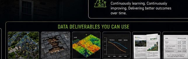
Downloadable files, annotated visuals, evidence folders, report notes, and context that stays tied to the captured record.
The record supports planning, maintenance, sale support, land management, access decisions, and future comparison.
NEDD provides documentation and decision-support records. Licensed engineering, legal, surveying, code, safety, or insurance determinations require the appropriate professional or authority.
Resource library.
120 article pages across roof/property, construction, municipal, land/forestry, insurance, and AssetGuard/reporting clusters.
Ice Dam Visual Documentation in Vermont
Roof, Storm & Property
View details →Snow Load Roof Documentation Before Winter Repairs
Roof, Storm & Property
View details →Commercial Roof Drone Data Reports
Roof, Storm & Property
View details →Roof Exterior Records for Property Managers
Roof, Storm & Property
View details →Drainage and Roof Edge Documentation
Roof, Storm & Property
View details →Storm Evidence for Property Owners
Roof, Storm & Property
View details →Before and After Roof Repair Documentation
Roof, Storm & Property
View details →What a Roof Data Report Can Show
Roof, Storm & Property
View details →Why Roof Photos Need Report Structure
Roof, Storm & Property
View details →Winter Roof Records for New England Properties
Roof, Storm & Property
View details →Rooftop Access Limitations and Drone Data
Roof, Storm & Property
View details →Property Condition Reports for Buyers
Roof, Storm & Property
View details →HOA Exterior Documentation Packages
Roof, Storm & Property
View details →Multi-Building Roof Monitoring
Roof, Storm & Property
View details →Seasonal Roof Comparison Records
Roof, Storm & Property
View details →Roof Documentation for Contractors
Roof, Storm & Property
View details →Exterior Wall and Facade Visual Records
Roof, Storm & Property
View details →Roof Report Turnaround and Weather Policy
Roof, Storm & Property
View details →How to Prepare for a Roof Drone Report
Roof, Storm & Property
View details →When to Request Professional Roof Review
Roof, Storm & Property
View details →Pre-Pour Drone Documentation for Contractors
Construction & Contractor Records
View details →Pre-Cover Records Before Work Gets Hidden
Construction & Contractor Records
View details →Construction Progress Drone Reports
Construction & Contractor Records
View details →Site Logistics Mapping for Contractors
Construction & Contractor Records
View details →Owner Contractor Dispute Evidence Folders
Construction & Contractor Records
View details →Before and After Site Documentation
Construction & Contractor Records
View details →Drone Site Records for Draw Meetings
Construction & Contractor Records
View details →Construction Access and Staging Visuals
Construction & Contractor Records
View details →As-Built Visual Records Without Waiting
Construction & Contractor Records
View details →Milestone Reporting for Developers
Construction & Contractor Records
View details →Material Movement Documentation
Construction & Contractor Records
View details →Cut Fill and Quantity-Support Records
Construction & Contractor Records
View details →Construction Delay Evidence Folders
Construction & Contractor Records
View details →Subcontractor Coordination With Site Records
Construction & Contractor Records
View details →Foundation and Slab Placement Documentation
Construction & Contractor Records
View details →Drone Records for Lenders and Owners
Construction & Contractor Records
View details →How to Build a Construction Photo Record
Construction & Contractor Records
View details →Weekly Construction Monitoring Packages
Construction & Contractor Records
View details →Project Closeout Visual Documentation
Construction & Contractor Records
View details →Why Organized Site Records Beat Scattered Photos
Construction & Contractor Records
View details →Municipal Culvert Drone Documentation
Municipal & Infrastructure
View details →Drainage Asset Records for Public Works
Municipal & Infrastructure
View details →Road Washout Evidence Folders
Municipal & Infrastructure
View details →Bridge and Drainage Visual Documentation
Municipal & Infrastructure
View details →Storm Readiness Records for Towns
Municipal & Infrastructure
View details →Public Works Drone Data Reports
Municipal & Infrastructure
View details →Asset Records for Small Municipalities
Municipal & Infrastructure
View details →Seasonal Comparison for Drainage Assets
Municipal & Infrastructure
View details →Facility Roof Documentation for Towns
Municipal & Infrastructure
View details →Roadside Infrastructure Visual Records
Municipal & Infrastructure
View details →Erosion and Slope Documentation
Municipal & Infrastructure
View details →Grant and Budget Planning Records
Municipal & Infrastructure
View details →Municipal Before and After Documentation
Municipal & Infrastructure
View details →How Towns Can Build Asset History
Municipal & Infrastructure
View details →Drone Data for Storm Response
Municipal & Infrastructure
View details →Culvert Inventory Support Reports
Municipal & Infrastructure
View details →Municipal Privacy and Data Handling
Municipal & Infrastructure
View details →When a Town Needs Engineer Review
Municipal & Infrastructure
View details →Public Works Recurring Monitoring
Municipal & Infrastructure
View details →Infrastructure Documentation Without Overpromising
Municipal & Infrastructure
View details →Drone Mapping for Vermont Landowners
Land, Forestry, Farm & Sugarbush
View details →Drone Mapping for New Hampshire Landowners
Land, Forestry, Farm & Sugarbush
View details →Sugarbush Storm Damage Documentation
Land, Forestry, Farm & Sugarbush
View details →Farm Access and Drainage Mapping
Land, Forestry, Farm & Sugarbush
View details →Forestry Damage Visual Records
Land, Forestry, Farm & Sugarbush
View details →Terrain and Access Route Documentation
Land, Forestry, Farm & Sugarbush
View details →Land Listing Data Packs
Land, Forestry, Farm & Sugarbush
View details →Boundary Visual Records and Limits
Land, Forestry, Farm & Sugarbush
View details →Rural Property Storm Evidence
Land, Forestry, Farm & Sugarbush
View details →Trail and Access Road Mapping
Land, Forestry, Farm & Sugarbush
View details →Vegetation and Canopy Visual Records
Land, Forestry, Farm & Sugarbush
View details →Farm Infrastructure Documentation
Land, Forestry, Farm & Sugarbush
View details →Sugarline and Access Corridor Records
Land, Forestry, Farm & Sugarbush
View details →Landowner Before and After Records
Land, Forestry, Farm & Sugarbush
View details →Mapping Support for Rural Planning
Land, Forestry, Farm & Sugarbush
View details →Outdoor Property Documentation Without Wildlife Targeting
Land, Forestry, Farm & Sugarbush
View details →Seasonal Land Comparison Reports
Land, Forestry, Farm & Sugarbush
View details →Water Flow and Washout Records
Land, Forestry, Farm & Sugarbush
View details →Large Parcel Evidence Folders
Land, Forestry, Farm & Sugarbush
View details →How Land Data Reports Support Decisions
Land, Forestry, Farm & Sugarbush
View details →Storm Damage Drone Documentation for Insurance Support
Insurance, Claims & Disputes
View details →Before After Evidence Folders
Insurance, Claims & Disputes
View details →Claim Support Without Guaranteeing Approval
Insurance, Claims & Disputes
View details →How Drone Reports Help Explain Visible Damage
Insurance, Claims & Disputes
View details →Property Damage Documentation After Wind Events
Insurance, Claims & Disputes
View details →Flood and Washout Evidence Records
Insurance, Claims & Disputes
View details →Contractor Dispute Documentation
Insurance, Claims & Disputes
View details →Insurance Documentation for Commercial Properties
Insurance, Claims & Disputes
View details →Why Dates and File Structure Matter
Insurance, Claims & Disputes
View details →Evidence Folders for Attorneys and Owners
Insurance, Claims & Disputes
View details →What an Insurance-Support Drone Report Includes
Insurance, Claims & Disputes
View details →How to Document Damage Before Cleanup
Insurance, Claims & Disputes
View details →Repair Planning With Visual Evidence
Insurance, Claims & Disputes
View details →When Drone Data Is Not Enough
Insurance, Claims & Disputes
View details →How to Prepare a Site for Damage Capture
Insurance, Claims & Disputes
View details →Organized Records for Adjuster Communication
Insurance, Claims & Disputes
View details →Documentation for Multi-Party Disputes
Insurance, Claims & Disputes
View details →The Difference Between Evidence and Opinion
Insurance, Claims & Disputes
View details →Privacy Rules for Claims Documentation
Insurance, Claims & Disputes
View details →Rush Storm Documentation Limits
Insurance, Claims & Disputes
View details →What Is a Drone Data Report
Reports, AssetGuard & 3D Renders
View details →Drone Data vs Drone Photography
Reports, AssetGuard & 3D Renders
View details →Why the Report Is More Valuable Than the Flight
Reports, AssetGuard & 3D Renders
View details →3D Renders From Drone Data
Reports, AssetGuard & 3D Renders
View details →AssetGuard Drone Intelligence Reports
Reports, AssetGuard & 3D Renders
View details →Recurring Asset Monitoring With Drone Data
Reports, AssetGuard & 3D Renders
View details →Estimate-Support Packages Explained
Reports, AssetGuard & 3D Renders
View details →Visual Evidence Folders Explained
Reports, AssetGuard & 3D Renders
View details →Capture Standards and Accuracy Language
Reports, AssetGuard & 3D Renders
View details →Data Handling for Drone Reports
Reports, AssetGuard & 3D Renders
View details →How Baseline Records Become Monitoring Programs
Reports, AssetGuard & 3D Renders
View details →Drone Report File Formats and Deliverables
Reports, AssetGuard & 3D Renders
View details →How AI-Assisted Reporting Should Be Used Safely
Reports, AssetGuard & 3D Renders
View details →How NEDD Explains Capture Methods by Scope
Reports, AssetGuard & 3D Renders
View details →Decision-Support Reports and Professional Boundaries
Reports, AssetGuard & 3D Renders
View details →How to Read a Drone Data Report
Reports, AssetGuard & 3D Renders
View details →What Makes a Drone Report Useful
Reports, AssetGuard & 3D Renders
View details →From Capture to AssetGuard Record
Reports, AssetGuard & 3D Renders
View details →Report Turnaround and Scope Factors
Reports, AssetGuard & 3D Renders
View details →How to Choose the Right Drone Data Package
Reports, AssetGuard & 3D Renders
View details →Choose the record that fits the decision.
NEDD helps organize visible evidence into files your team can use for repair planning, replacement decisions, claim communication, contractor coordination, budgeting, and future comparison.
Visible roof and exterior documentation before repair, replacement, or claim communication.
Storm / Fire / Loss RecordsOrganized post-event evidence before cleanup, contractor coordination, or claim discussions.
Repair or Replace SupportEvidence folders and estimate-support notes before major spend decisions.
Damage Over TimeBaseline records and follow-up captures for comparison over seasons, events, and repairs.
Construction ProgressMilestone, access, staging, and progress records for project communication.
Reports & DeliverablesReport packets, annotated imagery, map-style records, and evidence folders.